

Google reverse image search shows this as the original source: https://imgur.com/map-roads-of-canada-w7lDes8
it pretty funny what people in Ontario call North. Even North Bay is actually in the southern half. Timmins too.
Its because farther north than that is barely inhabited. North of roughly the orillia line, geography and community size changes dramatically compared to what is south of orillia. Its a good seperatation for political purposes as the needs and cultures in these smaller communities are different from the southern communities.
Northern Ontario starts at the French River, Orillia is just where the shield starts when driving from Toronto. Its an important geographic change but Kingston is practically in the shield too and I would hardly call that Northern Ontario
Its a good seperatation for political purposes
Until the mid '90s, the map on the wall in the public area at Queens Park was cropped off just west of Sudbury.
Something my friends in Thunder Bay found indicitave of the level of attention and support they got from the provincial government
It would honestly be reasonable for northern and southern Ontario to decide on a line and be managed seperately, if not become their own provinces. The gta takes too much of the provincial focus sometimes. Just look at ford’s temper tantrum over torontos bike lanes, the province as a whole has much bigger issues he should be addressing.
The North west is basically on fire year around now.
I don’t read this as Vancouver being isolated, I just read this as the prairies being victims/perpetrators of car dependent sprawl.
With a shit ton of complex geography, of course traffic is going to concentrate on a few main highways/roads
All of the agriculture and oil means there’s a road essentially on the whole survey grid too so that fills out a bunch of the map.
Totally. A bunch of roads all covering the farms. While in BC you won’t see “boat roads” for its huge water logistics.
Eh. I read it as BC not getting much funding for infrastructure from the feds, coupled with copious issues with development and treaties. BC’s population is overly concentrated in the GVRD, with almost half the provinces people living there. Part of the reason being the lack of infrastructure / job opportunities in other regions.
It’s taken two decades just to get a highway expansion in Vancouver that serves millions of people.
There’s a bridge over a canal on one of the only ways to Vancouver from the rest of Canada and it’s pretty much falling apart, it’s embarrassing. It’s practically a farm bridge.
Tourists and visitors from out of province all have to cross that thing and it must be a hell of an introduction to Vancouver. It’s not even regular width for a two lane road, constant crashes in it. Good luck if two semi trucks need to cross side by side.
I celebrate all of those things. Hopefully we perform as few highway expansion projects as possible and focus on rail instead. Also hopefully BC’s population remain concentrated in metro Vancouver so we preserve as much wilderness as possible instead of sprawling endlessly.
Never realized Vancouver was that isolated.
It’s been a hot topic over the years just how screwed Vancouver would be in the event of a disaster. The amount of ways out of the Lower Mainland can be counted on one hand.
I mean, we were kind of cut off from the rest of Canada just few years back already, when the floods washed out all the highways leading out of lower mainland. Friend was telling me his parents had to drive over 16 hours through US to get back to northern part of Okanagan Valley.
If you look closely at eastern PEI, you can see where the fields would be between the roads. Like it up with satellite imaging and you’ll see them there.
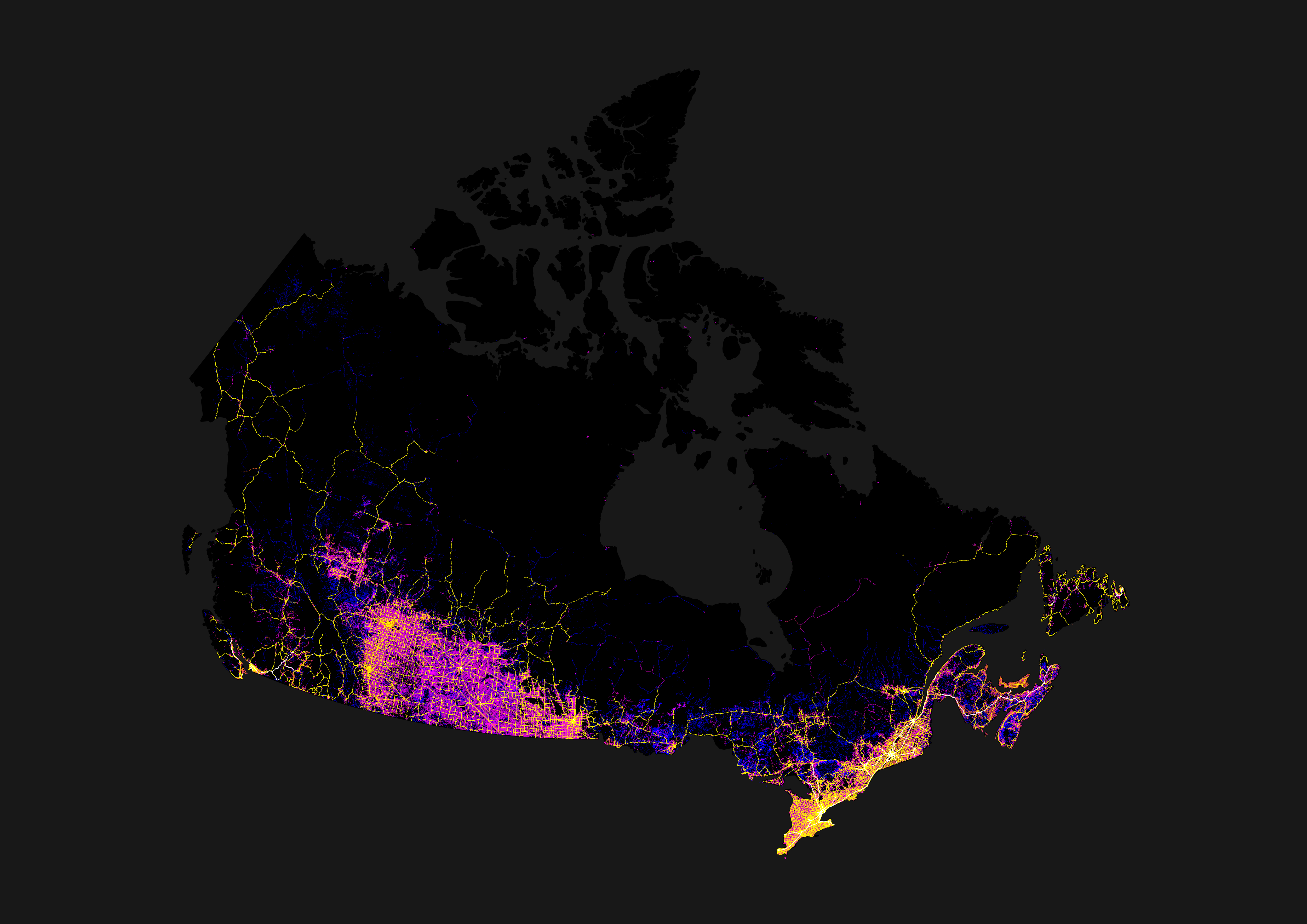
You can see the bit northeast of Thunder Bay where there is only one single major road connecting the entire East and the entire West.
Crazy how the whole northeast of Winnipeg is mostly dead.
I always found it funny driving through Thunder Bay to Winnipeg that it was called “northern Ontario” when you’re following the US border and landing squarely in southern Manitoba.
Manitoba should invade down that highway – see how the rest of Canada feels when the Riel Rebellion …
Ah nevermind, let bygones be bygones.
Saskatchewan, why are even your roads weird?
Which part? The southern prairie has ‘grid’ roads (magenta; literally roads in a grid, every mile E/W, every two N/S), with highways connecting the many towns and cities, settled because of agriculture. Then the northern shield (forest) has roads where they fit best to mainly indigenous communities.
with highways connecting the many towns and cities, settled because of agriculture.
And those towns were originally settled by farmers getting land adjacent to the railways, centered around the railway stations. They needed trains to get their produce to market, and to order their supplies from “the big city”.
Those early railroads had to build a water station about every 30 miles, as that was the distance the steam locomotives of the day could travel before needing to get more water. There were larger stations every 3rd or 4th water stop to re-supply with coal.
The history of the railroads is the history of Canada, especially so on the prairies.
If you look at Alberta and Manitoba, they also have the grid roads, but just looks more connected with a grid of highways following N/S or E/W. Saskatchewan’s highway system reminds me of nerve cells reaching out with all the angled highways spreading out from the cities.


