

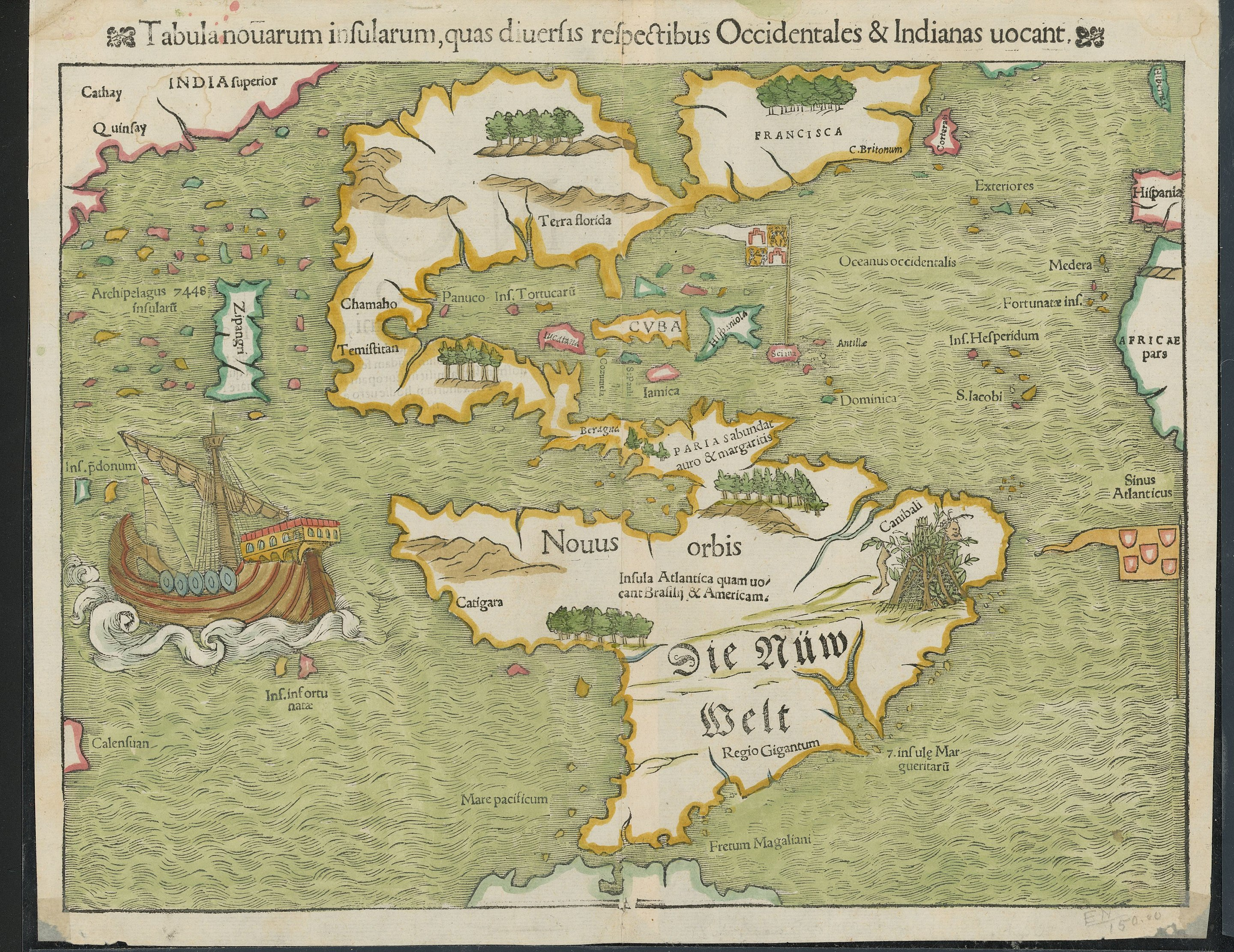
Now I really want to see an animation of what the European discovery of the planet looked like. Imagine a time lapse of a Civilization game, as the map is slowly revealed. I want to see that, except actual history.
Anyone know what Zipangri is? Could that be Baja California, or what?
Edit: Japan. Is apparently just off the coast of Mexico
Apparently Japan’s shape wasn’t well known either
I had guessed it was Sri Lanka since it is also shown just off the coast of India. Then I figured it was more likely Indonesia given it’s surrounded by so many other islands and not that close to India. But yeah, now that I know that the name meant Japan I’m wondering if it’s depiction on the map is a conflagration of accounts of Indonesia and Japan.
Given the lack of shape, it could be just about anything - I wonder if it was one report, or hearsay with no details and they filled in something
They were generally working with very, very rough, incomplete, conflicting, or confusing info, yes.
It’s pretty astounding to me that this is even remotely as accurate as it is.
Before seeing your comment and searching myself, I wondered if it was California as well, since it was thought that California was an Island for some time.
I really really want to find a good book or website showing the extended evolution of maps of the world or specific areas. This stuff fascinates me.
I’ve found a few minor ones over the years, but never a good one.
Sort of map-related, but the Longitude series/book is pretty fascinating. This map was drawn without really being able to calculate longitude except by dead reckoning.
I absolutely love wildly inaccurate old maps. They have so much charm.
is it inaccurate? I just see the state of Texas and from what I’m told it’s bigger than then the northern hemisphere.
Ships were huge in the 1500s!
So are we not gonna talk about the whole area labels for cannibals?
We are now.
What’d you want to talk about?
Do clowns really taste funny or nah?
And how many wipes do they need after dumping their girlfriend?
Musta been a cold day in North America.
How in sam hill are their vowel Vs and consonant Us in this‽
Pretty good map for the 16th century anyhow, except India being where Russia would be
“India” did not mean then what it does now.
“Regio Gigantum?” So below the Cannibals and Ze German Belt, lies the land of giants?
The only label on the map that’s both on Latin and in old German.
Sibera was part of India back then.
Man what a shit map, they are horrible at cartography /s
This dumbass didn’t even know the Maps app is free.


